
Orthomosaic photogrammetry is at the forefront of a mapping revolution, offering unparalleled precision and intricacy through its integration of drone technology and sophisticated software. At Skyland Pixels, LLC, we harness this innovative technique to transform aerial imagery into detailed, high-resolution maps, essential in various sectors including agriculture, environmental management, and urban planning.
This technology signifies a pivotal advancement in the field of aerial surveying. The use of drones, a hallmark of our operations at Skyland Pixels, enables us to capture comprehensive images from above, providing a level of detail and accuracy previously attainable only by advanced aerial vehicles.
In this blog post, we will delve deeper into the capabilities and broad applications of orthomosaic photogrammetry. We aim to illuminate how this technology not only enhances data quality but also revolutionizes our interaction with and understanding of the physical world. Join us at Skyland Pixels, LLC, as we explore the dynamic and transformative world of orthomosaic photogrammetry, a critical tool in the realm of modern aerial surveying.
Understanding Orthomosaic Photogrammetry
What is Orthomosaic Photogrammetry?
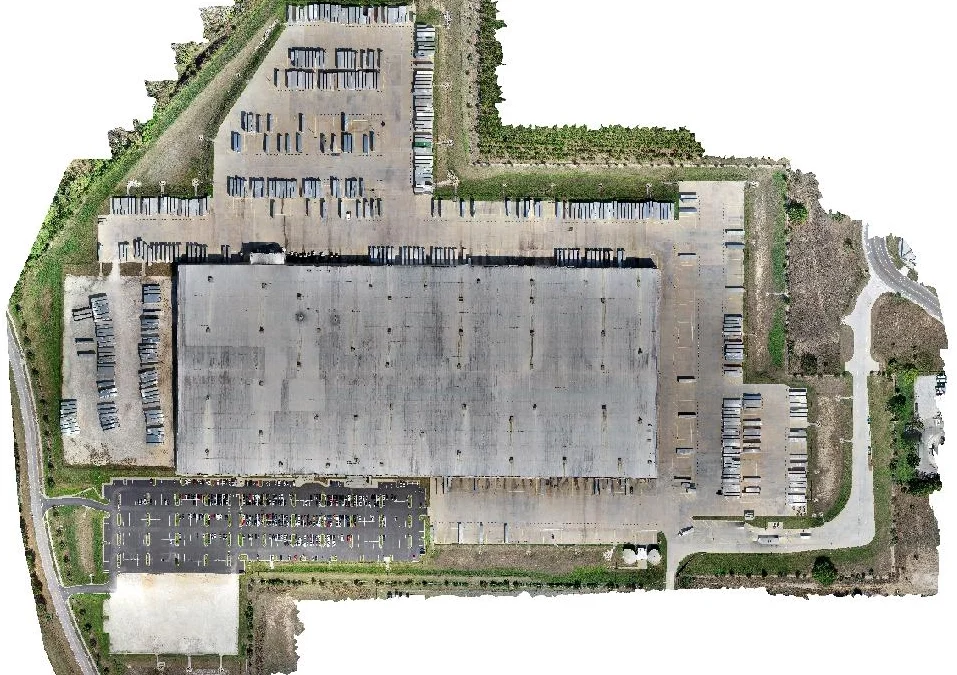
Orthomosaic photogrammetry represents a significant leap in mapping technology. It involves the process of stitching together a series of overlapping aerial photographs, taken by high-resolution cameras mounted on drones, into a single, comprehensive map. This map isn’t just a patchwork of images; it’s a carefully calibrated representation of an area, offering both high detail and topographic accuracy. This technique allows for the creation of maps that are both visually rich and geometrically accurate, making them invaluable tools across a variety of applications.


How Does It Work?
The magic of Orthomosaic photogrammetry begins with a drone flight, during which a series of overlapping images of the target area are captured. These images are then processed using specialized software that identifies common reference points between them. By aligning and stitching these images together, the software creates a coherent and continuous visual representation of the area. The result is an “Orthomosaic ” map — a map that is corrected for topographical distortions, ensuring consistent scale and true representation of the Earth’s surface.

Technology Behind the Process
The process of Orthomosaic photogrammetry relies heavily on sophisticated technology. The drones used are typically equipped with high-resolution cameras and advanced GPS systems to ensure precise image capture. The real prowess, however, lies in the software — powerful photogrammetry software that can process and stitch together thousands of images, considering factors like angle, light, and elevation, to create a seamless and distortion-free map. This combination of hardware and software is what allows for the creation of Orthomosaics that are not only visually stunning but also incredibly accurate and useful for a myriad of analytical purposes.
The Advantages of Orthomosaic Photogrammetry
Unmatched Accuracy and Detail
One of the most significant advantages of Orthomosaic photogrammetry is its ability to produce maps with unparalleled accuracy and detail. Unlike traditional mapping methods, which may suffer from scale inconsistencies and limited resolution, Orthomosaic s provide a true-to-scale representation of the surveyed area. This high level of detail is crucial for applications where precise measurements are paramount, such as land surveying, construction planning, and environmental monitoring.
Efficiency and Cost-Effectiveness
Orthomosaic photogrammetry significantly streamlines the mapping process. Traditional surveying methods can be time-consuming and labor-intensive, often requiring extensive manpower and physical resources. In contrast, drone-based photogrammetry can cover large areas in a shorter time, reducing both the time and cost involved in data collection. This efficiency makes it a practical solution for projects with limited budgets or tight timelines.
Versatility Across Environments
The flexibility of Orthomosaic photogrammetry is another key benefit. Drones can access areas that are challenging or dangerous for humans to navigate, such as steep terrain, dense forests, or disaster zones. This capability allows for comprehensive mapping in a variety of environments, expanding the scope of where and how mapping can be conducted.
Enhanced Data Integration and Analysis
Orthomosaic maps can be easily integrated with other geographic information systems (GIS) for enhanced data analysis. This compatibility is vital for professionals who rely on GIS for detailed spatial analysis and decision-making. Orthomosaic s provide a robust base layer over which other data sets, such as topographical, infrastructural, or environmental data, can be overlaid for more comprehensive analysis.
Applications in Different Industries
Revolutionizing Agriculture
• Precision Farming: Utilize Orthomosaic maps for detailed crop analysis, enhancing decision-making in precision agriculture.
• Land Management: Aid in farm layout planning, irrigation systems, and crop rotation management.
Transforming Urban Planning and Development
• Infrastructure Planning: Facilitate urban planning with detailed views for infrastructure design and land use assessment.
• Construction Monitoring: Use Orthomosaic s for real-time monitoring of urban construction projects, ensuring adherence to plans.
Empowering Construction and Engineering
• Site Analysis: Orthomosaic photogrammetry offers comprehensive site analysis, crucial for planning construction projects. It provides a detailed view of the terrain, surrounding structures, and access points.
• Project Monitoring and Reporting: Track the progress of construction projects accurately. These maps can be used for regular updates, stakeholder reporting, and ensuring project timelines are on track.
• Risk Assessment: Help in identifying potential risks and challenges in construction sites, such as uneven terrain, water accumulation areas, or proximity to sensitive zones.
Enhancing Environmental Conservation and Management
• Ecosystem Monitoring: Monitor environmental changes and plan conservation efforts effectively.
• Disaster Management: Assess damage and plan relief and rebuilding strategies post-disaster.
Archaeology and Historical Preservation
• Site Mapping: Map and study historical sites non-intrusively.
• Preservation Efforts: Monitor and preserve historical sites, documenting their current conditions.
Have Queststions Today? Start Here
Case Studies
Urban Growth and Planning: A Real-World Application
• Background: In the fast-paced world of urban development, Orthomosaic mapping has emerged as a key tool for analyzing urban growth and aiding efficient planning.
• Implementation: High-resolution aerial images were assembled to create Orthomosaic maps, offering a detailed and precise overview of urban landscapes.
• Outcome: These maps provided invaluable insights for urban planners, aiding in land use classification, change detection, infrastructure planning, environmental impact assessments, and spatial analysis. They facilitated the monitoring of urban growth, informed strategic planning, and helped predict future urban expansion.
• Impact: The integration of Orthomosaic data in urban planning led to more informed decisions, efficient resource allocation, and better project outcomes, showcasing the technology’s versatility in reshaping urban landscapes.
• Read More: For a detailed exploration of this application, visit Unlocking Urban Growth Insights with Orthomosaic Analysis.
Construction Site Monitoring: A Hypothetical Scenario
• Background: A construction company undertook a large-scale commercial development project, requiring precise coordination and progress monitoring.
• Challenge: Traditional monitoring methods were inadequate for the scale and complexity of the project.
• Solution: The company used Orthomosaic photogrammetry for detailed and regular aerial monitoring of the site.
• Implementation: Drones captured high-resolution images weekly, and processed them into Orthomosaic maps to provide a comprehensive view of the construction area.
• Results: The maps enabled accurate progress tracking, quick identification of discrepancies, efficient resource management, and enhanced safety measures.
• Conclusion: Orthomosaic photogrammetry was instrumental in ensuring the project’s timely and efficient completion, demonstrating its potential in modern construction project management.
The Future of Orthomosaic Photogrammetry
Technological Advancements
• Emerging Technologies: Discuss the integration of AI and machine learning with Orthomosaic photogrammetry, potentially leading to more automated and intelligent data analysis.
• Improved Drone and Camera Tech: Anticipate advancements in drone technology and camera capabilities, which would enhance the quality and efficiency of image capture, leading to even more detailed and accurate maps.
Expanding Applications
• Wider Industry Reach: Explore potential new industries where Orthomosaic photogrammetry could be applied, such as marine biology, forestry, and urban redevelopment.
• Enhanced Precision in Existing Fields: Predict how the technology could evolve to provide even more precision in areas like agriculture and construction, possibly impacting practices like micro-zoning in farming or real-time monitoring in construction.
Sustainability and Environmental Impact
• Climate Change Monitoring: Highlight the role of Orthomosaic photogrammetry in monitoring and combating climate change, including tracking changes in ecosystems and land use.
• Environmental Conservation: Discuss how advancements in this technology could lead to more effective conservation strategies, helping protect endangered habitats and species.
The Intersection with Big Data and IoT
• Integration with Big Data: Consider the potential of combining Orthomosaic data with big data analytics for more comprehensive insights into various phenomena.
• IoT Connectivity: Explore the possibilities that arise from integrating Orthomosaic photogrammetry with the Internet of Things (IoT), leading to smarter, data-driven decision-making in urban planning, agriculture, and environmental management.
Challenges and Considerations
• Addressing Privacy and Ethical Concerns: Acknowledge the ongoing need to address privacy and ethical considerations, especially as the technology becomes more pervasive and powerful.
• Navigating Regulatory Landscapes: Discuss the importance of staying abreast of and adapting to regulatory changes that could affect the use of drones and photogrammetry technology.
Integration with GIS and Data Analysis Platforms
Seamless Compatibility with GIS
• Enhancing GIS Data: Discuss how Orthomosaic maps can be integrated into Geographic Information Systems (GIS) to enrich the GIS data, providing a more detailed and accurate base layer for analysis.
• Application Examples: Describe practical examples, such as urban planning, where integrating Orthomosaic data with GIS has led to more informed decision-making and better outcomes.
Advanced-Data Analysis and Visualization
• Data Layering and Analysis: Explain how Orthomosaic maps can be layered with other data sets, such as demographic information, land use data, or climate patterns, to provide more comprehensive insights.
• Visualization Tools: Highlight the use of advanced visualization tools that can represent complex data sets visually, making it easier for analysts and decision-makers to understand and utilize the information.
Cross-Platform Data Integration
• Combining with Other Technologies: Explore the potential for integrating Orthomosaic photogrammetry with other emerging technologies, such as LiDAR or satellite imagery, to create even more comprehensive data sets.
• Real-World Application Scenarios: Provide examples of how this cross-platform data integration can be applied in real-world scenarios, such as environmental monitoring, disaster response, or infrastructure development.
Challenges and Opportunities in Data Integration
• Addressing Data Compatibility Issues: Discuss the challenges in ensuring compatibility between different data types and platforms and how these challenges can be overcome.
• Opportunities for Innovation: Emphasize the opportunities that arise from successfully integrating these diverse data sources, potentially leading to breakthroughs in how we analyze and understand complex systems and environments.
Legal and Ethical Considerations
Compliance with Drone Regulations

• Understanding Drone Laws: Outline the importance of complying with local and national drone regulations, which can vary widely in terms of airspace usage, drone operation, and data collection.
• Staying Informed: Emphasize the need for drone operators and users of Orthomosaic photogrammetry to stay informed about the latest regulations and obtain necessary permits or licenses.
Privacy Concerns and Data Protection
• Respecting Privacy: Discuss the privacy concerns that arise from aerial data collection, especially in populated or private areas and the importance of respecting individual privacy rights.
• Data Protection Measures: Highlight the measures that can be taken to protect the privacy of individuals, such as anonymizing data, securing data storage, and ensuring data is used ethically and responsibly.
Ethical Use of Photogrammetry Data
• Avoiding Misuse: Address the ethical implications of how Orthomosaic data is used, ensuring that it is not exploited for purposes that could harm individuals or communities.
• Promoting Positive Applications: Encourage the use of Orthomosaic photogrammetry for beneficial purposes, such as environmental conservation, disaster relief, and sustainable urban planning.
Impact on Communities and the Environment
• Community Engagement: Stress the importance of engaging with local communities when conducting large-scale mapping projects, ensuring transparency, and addressing any concerns.
• Environmental Considerations: Discuss the potential environmental impact of drone operations and mapping activities and the ways to minimize any negative effects, such as adhering to wildlife protection guidelines.
Training and Skills Development
Essential Skills for Orthomosaic Photogrammetry
• Technical Proficiency: Discuss the technical skills required to operate drones and process images into Orthomosaic maps, including knowledge of drone hardware, camera settings, and flight planning.
• Software Mastery: Emphasize the importance of proficiency in photogrammetry software for stitching images together and analyzing the resultant maps.
Training Programs and Certifications
• Formal Training Options: Highlight available training programs, workshops, or courses that provide education in drone operation, photogrammetry techniques, and data analysis.
• Certification Importance: Explain how obtaining certifications can not only enhance skills but also lend credibility and meet certain legal or professional standards.
Continuing Education and Skill Upgradation
• Staying Current: Underline the necessity of staying updated with the latest advancements in drone technology, software updates, and industry practices.
• Networking and Professional Development: Encourage participation in conferences, webinars, and online forums to exchange knowledge, learn from industry experts, and stay connected with the photogrammetry community.
Challenges in Skill Acquisition
• Overcoming Learning Curves: Acknowledge the challenges and learning curves associated with mastering Orthomosaic photogrammetry and suggest ways to navigate these, such as mentorship programs or hands-on training sessions.
• Adapting to Technological Changes: Discuss the need for adaptability in learning, given the fast-paced nature of technological advancements in the field.
FAQs and Common Challenges
Frequently Asked Questions
What is Orthomosaic Photogrammetry?
Orthomosaic photogrammetry is a method of mapping where numerous overlapping aerial photographs, typically taken by drones, are stitched together to create a single, highly detailed, and accurate map of an area. This process corrects for distortions that are typically found in individual images, resulting in a composite image that accurately represents the Earth's surface in both geometry and detail.
How Accurate are Orthomosaic Maps?
The accuracy of orthomosaic maps can be very high, often down to a few centimeters. This level of precision depends on various factors, including the quality of the camera on the drone, the altitude at which the images are captured, and the sophistication of the software used to stitch the images together. Under optimal conditions, orthomosaic maps can achieve a spatial resolution of up to 1 cm per pixel.
What Applications Does Orthomosaic Photogrammetry Have?
Orthomosaic photogrammetry has a wide range of applications across various industries. In agriculture, it's used for precision farming and crop monitoring. Urban planning and development benefit from its detailed mapping for land use planning and infrastructure development. In construction, it aids in site planning and monitoring progress. Environmental conservation efforts use it for ecosystem monitoring and climate change studies. It's also employed in archaeological surveys and historical site preservation.
What are the Legal Requirements for Drone Mapping?
The legal requirements for drone mapping vary by country and region but generally include compliance with airspace regulations, drone registration, and obtaining necessary permits or licenses for drone operation. Drone pilots may need to adhere to specific flight height restrictions, avoid flying in restricted zones, and ensure they don't invade privacy or create safety hazards. In some jurisdictions, commercial drone operations, which would include drone mapping, may require a certified pilot or additional permits. It's crucial to check and adhere to the local regulations of the area where the drone mapping will be conducted.
Common Challenges and Solutions
• Data Processing and Storage: Address the challenges in handling the large volumes of data generated and offer solutions like cloud storage and efficient data management systems.
• Image Quality and Accuracy: Discuss common issues with image quality and accuracy, and how they can be mitigated through proper drone operation, optimal weather conditions, and high-quality cameras.
• Navigating Regulatory Landscapes: Offer guidance on how to stay updated with changing drone regulations and ensure compliance.
• Integrating with Existing Systems: Talk about the challenges in integrating Orthomosaic data with other GIS or data analysis platforms and suggest strategies for seamless integration.
Overcoming Technical Obstacles
• Handling Complex Software: Provide tips for mastering complex photogrammetry software, possibly through training and practice.
• Adapting to Technological Advances: Advise on how to keep pace with rapid technological changes in drone and photogrammetry technology.
Practical Tips for Successful Implementation
• Best Practices for Drone Operation: Share best practices for conducting successful drone flights, such as pre-flight checks and adhering to safety guidelines.
• Maximizing the Utility of Orthomosaic Maps: Offer insights on how to extract the maximum value from Orthomosaic maps for different applications.
Conclusion
Recap of Key Points
• Versatile Technology: Reinforce how Orthomosaic photogrammetry has revolutionized mapping and surveying across diverse fields, offering unmatched accuracy and efficiency.
• Wide Range of Applications: Reiterate its applications in agriculture, urban planning, construction, environmental conservation, and more, highlighting its ability to provide detailed and actionable insights.
• Future Potential: Emphasize the promising future of Orthomosaic photogrammetry, considering technological advancements and expanding applications.
The Impact of Orthomosaic Photogrammetry
• Transformative Effects: Discuss how this technology is not just a tool for mapping but a transformative force in how we understand, interact with, and manage our physical world.
• Driving Informed Decisions: Highlight its role in enabling more informed decision-making in various sectors, thereby contributing to more sustainable and efficient practices.
Encouragement for Adoption and Learning
• Adoption in Various Sectors: Encourage businesses and professionals across different industries to consider how Orthomosaic photogrammetry can benefit their operations.
• Continuous Learning and Adaptation: Advocate for ongoing learning and adaptation in this rapidly evolving field, emphasizing the importance of staying up-to-date with the latest technological developments and regulatory changes.
Closing Thoughts
• Acknowledging Challenges and Opportunities: Acknowledge the challenges that come with adopting new technologies, while also pointing out the immense opportunities they present for innovation and growth.
• Invitation for Engagement: Invite readers to engage further with the subject, whether through seeking professional services, participating in training programs, or exploring the technology for their specific needs.
Connect with Us
Explore and Engage with Skyland Pixels, LLC
• Discover Our Resources: Dive into a wealth of knowledge on our website, where we regularly post articles and resources about the fascinating world of drone technology and Orthomosaic photogrammetry.
• Follow Our Journey: Stay on the pulse of the latest news and developments by following Skyland Pixels, LLC on social media. As we grow, you’ll get insights into our advancements and offerings.
Your Partnership Matters to Us
• Inquiries and Collaborations: If you see potential in Orthomosaic photogrammetry for your projects or business, we’re just an email away. Reach out to us for expert guidance and to discuss how our services can be tailored to your needs.
• Feedback and Suggestions: We value your perspective. Share your thoughts, experiences, or ideas in the comments, or suggest topics you’re curious about. Your input helps us grow and serve you better.