
What is Drone Surveying?
Drone surveying involves the use of unmanned aerial vehicles (UAVs) to capture high-resolution images and data from the air. By flying over a designated area, drones can collect highly detailed information about the terrain, structures, and objects below. This data is then processed to create accurate maps, models, and other survey outputs. The versatility of drones makes them ideal for use in construction, where precise data is critical for planning, monitoring, and execution of projects Source: Datumate.
Growing Importance in Construction
The use of drone surveying in construction has grown significantly in recent years, owing to the numerous benefits it offers. Drones help construction companies in five key areas: site analysis, planning and design, asset inventory, project reporting, and collaboration, as well as resolving disputes Source: Propelleraero.
Advantages Over Traditional Methods
To provide a coherent and informative context for the 3D model, you’ll want to include text that explains its relevance, purpose, and the details it represents. Given that this is about 3D modeling and topographic mapping, some of the points to consider are:
- Purpose of the Model: Explain what this 3D model aims to represent. Is it a specific geographical area, a type of terrain, or an architectural structure?
- Methodology: Briefly mention the techniques used to create the 3D model. Are these based on satellite data, LiDAR, drone imaging, or another method?
- Features Highlighted: Point out any specific features in the model that are significant, such as elevation changes, landmarks, or topographical details.
- Applications: Mention how this 3D model can be utilized. For example, is it for urban planning, geological analysis, environmental studies, etc.?
- Accuracy and Scale: Provide some information on the accuracy and scale of the model. How close to reality is the model, and what is the scale ratio?
Advanced Sensors and GPS Technology
Advanced Sensors Utilized in Drone Surveying
Drone surveying leverages an array of advanced sensors to collect data with exceptional accuracy and detail. Here’s a brief look at some of the key sensors used in this technology:
- LiDAR Sensors: These sensors emit laser pulses to measure distances precisely, allowing drones to create highly detailed 3D maps and models. Drones integrated with LiDAR sensors can autonomously adjust their paths to avoid obstacles, enhancing data collection efficiency (Source: PMT).
- IMU (Internal Measurement Unit): Comprising accelerometers and gyroscopes, IMUs gauge the drone’s orientation and motion, ensuring flight stability (Source: Aonic).
- Barometers: These sensors measure air pressure, which is crucial for maintaining consistent altitude and avoiding ground collisions (Source: Aonic).
- Multispectral Cameras: These cameras capture light at different wavelengths, providing detailed data for vegetation analysis, land use, and more. This is particularly useful for construction planning and environmental impact assessments (Source: Sitech SW).
- RGB Cameras: Commonly used to capture standard images, these cameras provide high-resolution images that are essential for creating detailed maps and models (Source: Sitech SW).
The Role of GPS Technology in Drone Surveying
GPS technology is pivotal in drone surveying, enabling precise navigation and stable positioning. Here’s how it works:
- Accurate Navigation: GPS helps drones move precisely and maintain stable positions. This is critical for capturing high-quality aerial data and ensuring consistent results (Source: Umiles Group).
- Precise Positioning and Georeferencing: While in flight, drones collect raw GPS data from an active base station on the ground. This data, combined with onboard observations, allows the drone to accurately determine its position relative to the base, ensuring precise measurements (Source: Propeller Aero).
Enabling Precise Measurements and Data Collection
Combining advanced sensors and GPS technology in drone surveying brings several benefits:
- High Accuracy: Advanced sensors, such as LiDAR and multispectral cameras, capture comprehensive data points, resulting in highly accurate measurements of distances, elevations, surfaces, and volumes (Source: Wingtra).
- Comprehensive Data Capture: Drones collect multiple images from different angles, ensuring thorough overlap for accurate mapping and 3D model creation (Source: Autodesk).
Advanced sensors and GPS technology are revolutionizing drone surveying by providing construction companies with precise, reliable data, ultimately leading to better project planning and execution
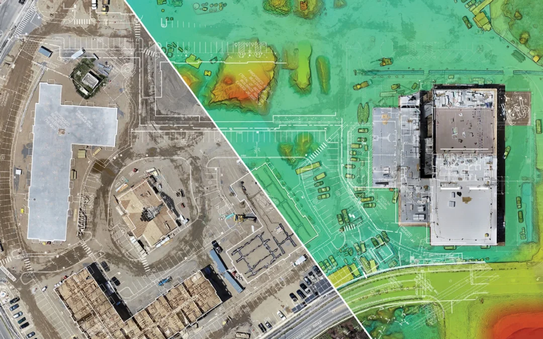
3D Modeling and Topographic Mapping
The 3D model displayed showcases a detailed representation of the 3D Model of Michigan Central Station created using advanced topographic mapping techniques. Leveraging methodology and photogrammetry, this model captures the intricate details of the terrain with high precision.

Key Features:
- Elevation Changes: The model accurately displays elevation contours, enabling a clear understanding of the terrain’s topography.
- Landmarks and Features: Notable landmarks and natural features are highlighted, providing valuable insights for analysis and decision-making.
- Scale and Accuracy: The model maintains a high accuracy level, ensuring that the depicted features closely represent real-world dimensions.
Applications: This model is a crucial tool for various applications, including:
- Urban Planning: Assisting city planners in visualizing and designing urban landscapes.
- Geological Studies: Facilitating the analysis of geological formations and structures.
- Environmental Monitoring: Enabling detailed observation of environmental changes and assessing impacts.
By integrating cutting-edge technology and precise data collection methods, this 3D model serves as an indispensable resource for professionals in various fields, offering a comprehensive view of the mapped area for enhanced understanding and decision-making.
Utilizing Drone Surveying Data
The leap in technology has made it possible for drones to capture stunningly precise data, which is then used in the creation of intricate 3D models and topographic maps. The process involves drones flying over an area, capturing high-resolution images from multiple vantage points. These images are then processed using photogrammetry software to create orthomosaics and 3D models. Each individual data point has specific X, Y, and Z coordinates representing latitude, longitude, and elevation, which is essential for detailed mapping.
Benefits of 3D Modeling and Topographic Mapping
Employing 3D models and topographic maps offers several key benefits for construction projects:
- Improved Design Visualization: These models allow for better planning and visualization, aiding stakeholders in understanding the project’s scope and intricacies without needing to visit the site. Source: LetsBuild
- Precision and Accuracy: The data collected and modeled is accurate to within a few centimeters, which drastically reduces errors in project planning and execution. Source: Propeller Aero
- Enhanced Collaboration: These visualizations make it easier for different teams (engineering, design, and construction) to collaborate, as they can all base their work on the same accurate models. Source: Novatr
- Risk and Safety Analysis: The models help in identifying potential problem areas, which contributes to better risk management and safety planning. Source: TruePoint Scanning
- Efficient Facility Management: Post-construction, the same models can be used for facility management, making maintenance and modifications simpler and more informed. Source: J Scott Smith
Have Questions Today? Start Here
Case Studies and Applications
Many construction firms have already made use of these technologies with notable successes:
- Earthworks Projects: By implementing 3D modeling, projects have seen increased plan accuracy and reduced surveying error, saving both time and money. Source: Takeoff Pros
- Progress Tracking: Accurate 3D modeling allows project managers to visualize progress at every stage, compare it against plans, and predict future progress better. Source: Propeller Aero
Conclusion
With the ability to create precise, easily interpretable 3D models and topographic maps, drone surveying has become an indispensable tool for construction projects. These models streamline operations, improve accuracy, and enhance collaboration, providing numerous advantages from the planning phases through to facility management. As technology continues to advance, the scope and efficiency of these surveys are only set to increase, making them a wise investment for any construction company.
Streamlining Project Execution with Drone Surveying for Construction in Orlando
Boosting Efficiency in Site Surveys
Drones make site surveys swift and precise. Traditional land-based surveys can be time-consuming and labor-intensive, but drones can cover large areas quickly and with minimal manpower. For example, capturing topographic data with a drone is up to five times faster than conventional methods, saving both time and money Source: Wingtra. This efficiency allows construction teams to reallocate resources to more specialized tasks, enhancing overall productivity.
Reducing Costs
By streamlining survey processes, drones significantly cut down expenses. Traditional manual surveys often require a lot of equipment and labor, which can be costly. Drones, on the other hand, can perform these tasks more cheaply and efficiently. Mid-level drones for mapping small sites can cost less than $2,000, and even more advanced mapping equipment ranges from $10,000 to $100,000 Source: Jouav. This results in substantial cost savings, as drones expedite the surveying process by surveying up to 120 acres per hour compared to the traditional five acres per hour Source: Drones Technology.
Enhanced Safety
Using drones for site inspections keeps workers out of hazardous areas, minimizing the risk of accidents. Drones equipped with high-resolution cameras and LiDAR can identify potential jobsite hazards before they become safety risks Source: The Drone Life NJ. This enhanced visibility enables construction managers to make more informed decisions and implement necessary safety measures proactively.
Improving Monitoring and Communication
Routine aerial inspections via drones provide real-time images and videos, allowing project managers to oversee construction progress continually. This is particularly beneficial for large-scale projects where on-the-ground inspections can be time-consuming, offering a clear, up-to-date picture of the entire site Source: Leading Edge Drones. Improved communication through these visuals helps keep projects on track and ensures that any issues are promptly addressed.
Examples of Streamlined Processes
Earthworks: Drone surveying provides precise volumetric calculations for earthworks, saving time and reducing human error. For instance, the data collected can be used to manage cut and fill operations more accurately, minimizing waste and maximizing efficiency.
- Structural Inspections: Drones can access hard-to-reach areas and identify defects without putting workers in risky situations, thus improving the efficiency and safety of inspections Source: Drones Technology.
Progress Tracking: Regular updates through drone photography and videography provide a clear record of construction progress, which can be shared with stakeholders, thus streamlining project management and collaboration efforts.
By significantly enhancing efficiency, reducing costs, improving safety, and providing better monitoring and communication tools, drone surveying streamlines construction project execution. This technology allows construction companies to deliver projects faster and more efficiently, while also addressing potential risks proactively.
The Orlando Advantage
Localized Benefits of Drone Surveying in Orlando
Drone surveying offers distinct advantages for construction companies operating in Orlando. The region’s unique terrain and environmental factors, such as wetlands and diverse topography, can present significant challenges for traditional surveying methods. However, drones equipped with advanced sensors and GPS technology can easily navigate these obstacles, providing accurate and comprehensive data collection without the need for physical land traversal Source: Medium.
Addressing Local Environmental Challenges
Orlando’s lush landscapes, water bodies, and variable terrain can be both a charm and a challenge for land surveyors. Traditional methods would involve extensive manual effort and potential safety risks. Drone technology, on the other hand, can handle these complexities with ease. Advanced drones can capture high-resolution orthomosaics and create detailed 3D models even in hard-to-reach areas, providing critical data with minimal environmental impact Source: Wingtra.
Enhanced Safety and Efficiency
One of the most significant benefits of drone surveying in the construction sector is the improvement in safety. Drones can perform aerial surveys and inspections, reducing the necessity for workers to access hazardous areas. This minimizes the risk of accidents and injuries, fostering a safer work environment. Additionally, drones can gather data up to five times faster than traditional methods, which translates to reduced field time and lower costs Source: Wingtra.
Cost and Time Savings
The economic benefits of drone surveying are particularly notable in Orlando. The ability to quickly capture and process data means that projects can progress more rapidly, reducing delays and saving on both time and labor costs. The reduced need for manual surveying equipment and the minimized labor involved also cut down on project expenses significantly Source: Propeller Aero.
Streamlined Project Execution
Real-time data obtained from drones aids in better project management and decision-making. Having access to up-to-date information allows for more efficient planning and execution of construction projects. By facilitating better communication and collaboration among stakeholders, drone data helps keep projects on track, ultimately leading to timely completion and adherence to budgets Source: Hunter Labour Hire.
Overcoming Adoption Barriers
Despite the benefits, barriers such as regulatory challenges, technical limitations, and high initial costs can deter companies from adopting drone technology. However, the long-term advantages, including cost savings, efficiency, and improved safety, far outweigh these initial hurdles. As more companies witness the substantial ROI from drone adoption, the shift towards this technology in Orlando’s construction landscape continues to gain momentum Source: MDPI.
Conclusion
The adoption of drone surveying in Orlando provides construction companies with a significant edge. By addressing local environmental challenges, enhancing safety, and offering cost and time savings, drones are revolutionizing the construction industry. Companies that invest in this technology can expect streamlined project execution and superior outcomes. It’s time for construction firms in Orlando to embrace drone surveying and reap its myriad benefits.
Conclusion
Unleashing the Potential of Drone Surveying
Drone surveying represents a seismic shift in how construction projects are executed, merging technological advancement with practical efficiency. For construction companies in Orlando, the advantages stretch far beyond mapping and data collection. Primarily, drones offer unparalleled precision, significantly reducing human error. The integration of advanced sensors and GPS ensures that data is not only accurate but collected swiftly, which is critical in a fast-paced industry.
Enhanced Safety and Resource Optimization
Safety, a cornerstone of successful construction, sees remarkable improvement with drone technology. By conducting aerial surveys and inspections, drones keep workers out of potentially hazardous zones, thereby minimizing accidents and injuries Source: LinkedIn. This isn’t just about safety; it’s also about resource optimization. Less time and fewer man-hours spent on ground-based surveys translate to lower operational costs and higher productivity.
Streamlined Project Execution
Drone surveying accelerates project timelines by capturing topographic data up to five times faster compared to traditional methods . This swift data collection, combined with technologies like PPK geo-tagging, means survey results are delivered quicker and at a lower cost. This efficiency is paramount in keeping projects on track and under budget.
The Unique Orlando Advantage
Orlando’s construction landscape poses specific challenges, from varying terrain to regulatory constraints. Here, drones offer a distinct edge, allowing companies to navigate these hurdles with ease. The ability to produce real-time visuals and data enhances communication among project stakeholders, ensuring everyone stays informed and aligned. Moreover, the investment in drone technology pays off rapidly through reduced rework and delays, enhancing overall project quality.
Looking Ahead
The integration of drone surveying into construction projects in Orlando is not just a futuristic idea; it’s a current necessity. The benefits are multi-fold: increased accuracy, enhanced safety, streamlined processes, and significant cost savings. These advantages make a compelling case for construction companies to adopt this technology. By leveraging drone surveying, Orlando’s construction companies can stay ahead of industry standards, deliver superior projects, and cement their reputation as innovative leaders in the field. Don’t let the opportunity slip by—consider integrating drone surveying into your next construction project and witness the transformative impact it brings.
Take the Next Step with Skyland Pixels
At Skyland Pixels, we understand the pivotal role of cutting-edge technology in driving construction projects to success. Our expertise in drone mapping can be the catalyst for optimizing your construction outcomes, ensuring that every project is a testament to precision, efficiency, and excellence.
Don’t let your projects be grounded by traditional limitations. Take the next step into the future of construction with Skyland Pixels. Visit www.skylandpixels.com/construction to learn more about our drone mapping services and how we can elevate your construction projects to new heights.
Get in Touch Today!
Ready to transform your construction projects with advanced drone mapping solutions? Contact Skyland Pixels today at www.skylandpixels.com and discover how our expertise can bring your visions to reality, one flight at a time.
In this concluding section, we’ve encapsulated the key insights discussed in the article, reaffirmed the transformative potential of drone mapping in construction, and provided a clear, compelling call to action. This structure ensures that readers leave with a clear understanding of the value proposition and are motivated to engage further with your services.
Frequently Asked Questions (FAQs)
What is drone surveying and how does it work?
Drone surveying involves using unmanned aerial vehicles (UAVs) equipped with various sensors, such as cameras and LiDAR, to capture high-resolution images and data of a construction site. This data is then processed to create detailed maps, 3D models, and orthomosaics, which can be used for planning, monitoring, and managing construction projects.
How accurate is drone surveying compared to traditional methods?
Drone surveying can achieve high levels of accuracy, often within a few centimeters, depending on the equipment used and the conditions of the survey. Advanced technologies like GPS and RTK/PPK positioning further enhance precision, making drone surveys highly reliable.
What types of sensors are typically used in drone surveying?
Common sensors include high-resolution optical cameras, LiDAR (Light Detection and Ranging) systems, thermal cameras, and multispectral sensors. The choice of sensor depends on the specific requirements of the project, such as topographic mapping, volumetric measurements, or thermal inspections.
What are the initial costs associated with adopting drone technology for surveying?
The cost of drone equipment can range from a few thousand dollars for mid-level drones to upwards of $100,000 for advanced mapping systems. Additionally, there are costs for software, training, and potentially hiring skilled operators. However, these initial investments can be offset by the long-term savings in time, labor, and resources.
Are there any regulatory requirements for using drones in construction?
Yes, drone usage is subject to regulations, which vary by country and region. In the U.S., for example, the Federal Aviation Administration (FAA) requires commercial drone operators to obtain a Part 107 certification. Operators must follow rules regarding flight altitude, airspace restrictions, and line-of-sight operation.
How do drones improve safety on construction sites?
Drones minimize the need for workers to enter hazardous areas by performing aerial surveys and inspections. This reduces the risk of accidents and injuries, enhancing overall site safety. They can also quickly identify potential safety hazards, allowing for proactive measures to be taken.
Can drone surveys be conducted in all weather conditions?
While drones can operate in various conditions, certain weather factors like heavy rain, strong winds, and fog can impede their performance and data accuracy. It's essential to conduct surveys during favorable weather conditions to ensure optimal results.
How long does it take to process the data collected by drones?
Data processing times can vary depending on the volume of data and the complexity of the project. Typically, advanced software can process and generate usable outputs within a few hours to a few days. This is significantly faster compared to traditional survey methods.
What are the environmental benefits of using drones for surveying?
Drones have a lower environmental impact compared to traditional methods as they eliminate the need for extensive physical land traversal, which can disrupt ecosystems. They also reduce the carbon footprint associated with the use of heavy equipment and vehicles.
How do drones facilitate better communication and collaboration among project stakeholders?
Drones provide real-time data and visual updates, which can be easily shared with all stakeholders involved in a project. This improved visibility and accessibility of information enable better decision-making, streamlined processes, and enhanced collaboration.
Connect with Skyland Pixels
If you’re looking for a reliable and experienced partner and ready to integrate drone mapping into your next project, our team at Skyland Pixels is here to guide you. We provide tailored drone mapping solutions that align with your project’s specific needs and goals.
Get in Touch Today!
Transform your construction projects with the precision and efficiency of drone mapping. Visit www.skylandpixels.com or reach out directly to embark on a journey of innovation and success with us.
Ready to revolutionize your data collection and analysis? Contact us now for a free consultation.
• Email: info@skylandpixels.com
• Phone: (651) 955-6329
• Website: www.skylandpixels.com
We look forward to partnering with you for all your drone survey needs!